• In January 2015, the Ministry of Land, Infrastructure, Transport and Tourism in Japan issued a new disaster management policy to prevent and mitigate the impacts of more intense disasters. Accordingly, the Flood Control Act was partially revised in May 2015 to include provisions for strengthening of soft measures against the largest possible scale of river flooding, urban flooding, and storm surges.
• For this revision, the government divided the country into 15 zones consisting of areas with similar rainfall characteristics. DAD analysis was conducted for each zone’s past rainfall data, and the largest possible rainfall was calculated for various durations and rainfall area sizes. The results were used to identify flood risk areas and create flood hazard maps, but without considering climate change impacts.
• In 2016, an ensemble climate prediction database (d4PDF) was developed to address the impacts of global warming. This database has a resolution of 60 km worldwide and 20 km in the Japan region. In December 2023, under the government-led SENTAN program, the resolution was further improved to 5 km, thus setting the conditions for implementing projects while factoring in the impact of climate change.
• In an announcement issued by the Japan Meteorological Agency about the heavy rain in July 2018 in Western Japan, the agency suggested that the increase in water vapor content in the atmosphere due to global warming may have contributed to the event. Therefore, it is increasingly important to plan and implement soft measures while considering the impact of climate change.
• To quantify the impact of climate change on the largest possible rainfall by calculating the rainfall change rate using the large-scale ensemble dataset of d4PDF with a resolution of 5km.
• To provide the rainfall change rate calculated while factoring in the impact of climate change to revise soft measures, such as updating flood hazard maps, while considering climate change impacts.
FY2022-FY2024
| Chief Researcher | KUBOTA Keijiro |
| Senior Researchers | USHIYAMA Tomoki, TANAKA Yozo |
| Research Specialist | Ralph Allen Acierto |
• The research is underway focusing on the northwestern and southeastern parts of Kyushu among the 15 zones.
• The 5 km d4PDF dataset used for this research covers the present climate for 60 years from 1950 to 2010 and the future +4K climate for 60 years from 2050 to 2110 for each of the 12 ensembles (i.e., 720 years of data in total for either case). DAD analysis was conducted for present and future rainfall in northwestern and southwestern Kyushu.
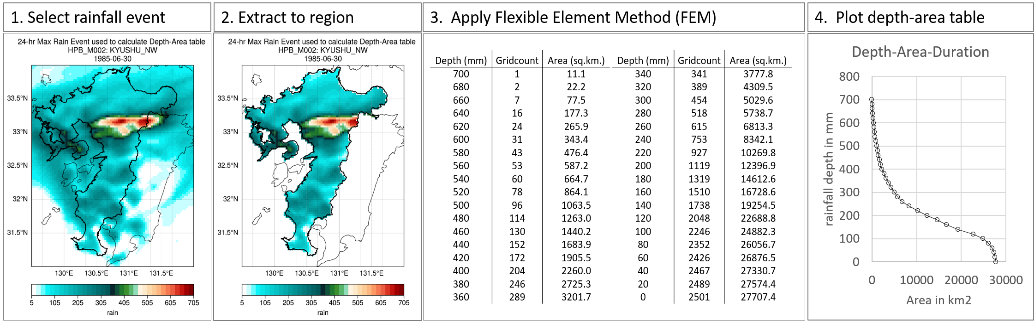
• Figure 1 shows an example of DAD analysis conducted for a rainfall event. In Step 1, we selected an event from the listed heavy rainfall events. In Step 2, we extracted the rainfall in the target area. In Step 3, based on the manual published by WMO in 1969, we produced a table of accumulated rainfall and rainfall area acquired using the Flexible Element Method. In Step 4, we created a graph based on the table.
• In order to estimate the impact of climate change, we compared the results of DAD analysis using present and future climate data and calculated the rainfall change rate. The results revealed for the first time that the average rainfall change rate under the +4K scenario would be 1.05 to 1.34 in northwestern Kyushu and 1.07 to 1.31 in southeastern Kyushu. These results are considered valid, as Kawase et al. (2023) reported a rainfall change rate of 1.26 for 1-hour accumulated rainfall with an annual exceedance probability of 1/100.